About
Overview
- Scope: Establish a virtual hydrologic observatory, and provide direction for building new infrastructure in an actual observatory.
- Focus: Build infrastructure for improving the knowledge base for sound hydrologic management in the Sierra Nevada, San Joaquin Valley and across the West.
Science Questions
- How do hydrologic systems respond to multiple perturbations?
- How do pulses and changes propagate through the hydrologic system?
- What are the time lags and delays of stresses in different systems?
- How can the predictive ability for these responses be improved?
Specific Aims
- Formulate basin-scale measurement and modeling strategies to meet priority research issues, through analysis of existing operational and research data.
- Assess different instrument cluster designs to provide the ground-based measurements needed for hydrologic process research.
Planning Area
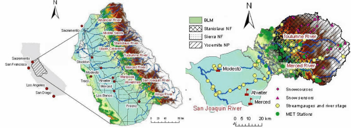
The hydrologic observatory planning area is the greater San Joaquin Watershed encompassing the American River to the north through the Kings River in the south. The watershed covers a total area of 59,900 km2. The test basins for the current project, the Merced and Tuolumne, together cover an area of 11,230 km2.

Design Concept and Challenges
- Observatory design concept: Establish intensive measurements at ground-based instrument clusters, integrated with broad coverage offered by satellite remote sensing, plus operational networks.
- Science challenge: Scaling between the instrument clusters is a major challenge. Basing an observatory design on instrument clusters at representative points across the landscape recognizes that it is logistically infeasible to measure everything, everywhere, all the time. Instrument clusters co-locate key measurements, in order to illuminate linkages among processes within each cluster's relatively small footprint.
- Design challenges: Configure instrument clusters to maximize the scientific payoff for a given investment of resources. Determine how well the data from these clusters represent the landscape that surrounds them, beyond the footprint of the measurements themselves.
Link to Applications
This project addresses the gap between the demonstrated demand for new hydrologic information on the part of decision-makers, researchers and other stakeholders versus the ever increasing supply of information, especially new information from satellite remote sensing, embedded sensor networks & numerical models that help integrate satellite and ground-based measurements. The potential impact on the management of water & other natural resources is enormous.
Main Activities
- Assemble and evaluate core data, with emphasis on data that are not in national data systems, or in some cases not in any accessible data system.
- Evaluate available model output at the basin, watershed and site scales to both assess where there are strengths and weaknesses in measurements and to assess strategies for developing spatial data sets for model evaluation, validation and prediction.
- Examine spatial properties across the study area to both quantitatively determine watershed-scale variability and to develop a strategy for sampling that variability.
- Assess prototype instrument cluster designs, for mountain, riparian and valley environments. This assessment will influence ongoing expansion of instrument clusters in the observatory.
- Integration of these analysis by the observatory design team into a virtual observatory, yielding both a distilled science agenda to guide observatory development and a blueprint for expansion of measurement systems.
Cyberinfrastructure
- Role: Having a flexible, multi-portal data and information system is absolutely critical and should precede large-scale physical observatory development.
- Approach: Link local datasets with national datasets through digital library and digital watershed tools developed by CUAHSI HIS team and others. Ingest local data not currently in data systems.
- Partners: CUAHSI Hydrologic Information Systems (HIS) team(s), Western Regional Climate Center.
Example Data
- Daily satellite data on snowpack spatial extent and albedo, plus blended snow water equivalent products.
- Streamflow, weather station and point snow data from operational and research networks.
- Soil moisture and water quality data from research networks.
- Topography, vegetation characteristics and other spatial data layers from multiple sources.
Project
- Duration: July 2006-June 2008.
- Funding: $307,678 from the National Science foundation (NSF) and Consortium of Universities for the Advancement of Hydrologic Science, Inc. (CUAHSI).
Observatory Design Team
| UC Merced (PI and team leader) | |
| UC Berkeley (catchment biogeochemistry) | |
| UC San Diego/Scripps (hydroclimatology) | |
| UC Merced (groundwater-surface water interactions & education) | |
| UC Santa Barbara (satellite remote sensing & cyberinfrastructure) | |
| UC Davis (groundwater hydrology) | |
| UC Merced (water quality & sensor networks) | |
| UC Berkeley (geomorphology & catchment biogeochemistry) | |
| Berkeley National Lab (hydrologic modeling) | |
| UC Los Angeles (snow hydrology & measurement design) | |
| Desert Research Institute (climate & cyberinfrastructure) |